(1 of 2) ...The Flood Warning is extended for the following river and locations in western Indiana... White River at Edwardsport. White River at Elliston. .Rainfall amounts within the past few days of two to four inches across central Indiana is producing minor flooding along the White River in western Indiana. Additional rainfall of a quarter to three quarters of an inch is possible through Monday evening. * WHAT...Minor flooding is forecast. * WHERE...White River at Elliston. * WHEN...Until Monday afternoon. * IMPACTS...At 20.0 feet, River Road north of CR 150 W in Greene County is flooded. Low agricultural fields flood. * ADDITIONAL DETAILS... - There is no current observed data. - Forecast...The river is expected to fall below flood stage early Monday morning and continue falling and remain below flood stage. - Flood stage is 18.0 feet. - http://www.weather.gov/safety/flood (2 of 2) ...The Flood Warning is extended for the following river and locations in western Indiana... White River at Edwardsport. White River at Elliston. .Rainfall amounts within the past few days of two to four inches across central Indiana is producing minor flooding along the White River in western Indiana. Additional rainfall of a quarter to three quarters of an inch is possible through Monday evening. * WHAT...Minor flooding is occurring and minor flooding is forecast. * WHERE...White River at Edwardsport. * WHEN...Until late Tuesday evening. * IMPACTS...At 17.5 feet, Flooding closes Old Vincennes Road. High water crosses SR 358 on the Daviess County side just west of the levee. Flooding begins to affect higher bottomlands. Residential property of river cabins begins to flood. * ADDITIONAL DETAILS... - At 7:00 PM EDT Saturday /6:00 PM CDT Saturday/ the stage was 17.4 feet. - Recent Activity...The maximum river stage in the 24 hours ending at 7:00 PM EDT Saturday /6:00 PM CDT Saturday/ was 17.4 feet. - Forecast...The river is expected to fall below flood stage late Tuesday morning and continue falling and remain below flood stage. - Flood stage is 15.0 feet. - http://www.weather.gov/safety/flood
RepeaterBook.com Home Page
honey pot West lafayette, Indiana, 462.675, WRUZ381 Repeater

West lafayette, IN

WRUZ381

GMRS Repeater ID: 18-1551
Downlink: 462.675
Uplink: 467.675
Uplink Tone: LOG IN TO VIEW
Downlink Tone: LOG IN TO VIEW
County: Tippecanoe
GPS*:
Owner: WRUZ381
Use: OPEN
Op Status: ON-AIR On-Air
Coverage: Medium
20 mi radius.
Sponsor: Gmrs Lafayette
Notes: This repeater is open to all GMRS license holders. Feel free to get on the repeater and chat with others. This repeater is here for fun times and nice conversations.
Marker
30 km
20 mi
Leaflet © OSM contributors

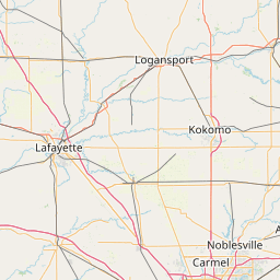
Exact coordinates of the repeater are not known.
Coverage circle based on mobile coverage and ignores propagation anomalies and terrain.

Signal Reports (click map icon for details): Base Mobile HT
Add a Signal Report