(1 of 2) ...The National Weather Service in Jackson MS has issued a Flood Warning for the following rivers in Mississippi... Tuscolameta Creek At Walnut Grove affecting Leake County. * WHAT...Minor flooding is occurring and minor flooding is forecast. * WHERE...Tuscolameta Creek at Walnut Grove. * WHEN...From this morning to late tomorrow morning. * IMPACTS...At 27.0 feet, Agricultural land along the river is flooding. * ADDITIONAL DETAILS... - At 11:00 AM CDT Monday the stage was 27.2 feet. - Forecast...The river has crested and is expected to fall below flood stage late this afternoon. - Flood stage is 25.0 feet. - http://www.weather.gov/safety/flood (2 of 2) ...The Flood Warning continues for the following rivers in Mississippi... Noxubee River At Macon affecting Noxubee County. * WHAT...Minor flooding is occurring and minor flooding is forecast. * WHERE...Noxubee River at Macon. * WHEN...Until early Friday morning. * IMPACTS...At 31.0 feet, Water covers roadway leading from cattle farmland to chicken coops downstream of Highway 45 bridge on the left side. * ADDITIONAL DETAILS... - At 11:00 AM CDT Monday the stage was 29.6 feet. - Forecast...The river is expected to rise to a crest of 31.3 feet early tomorrow afternoon. - Flood stage is 28.0 feet. - Flood History...This crest compares to a previous crest of 31.3 feet on 03/06/2020. - http://www.weather.gov/safety/flood
RepeaterBook.com Home Page
honey pot Vancleave, Mississippi, 462.650, WSBQ741 Repeater

Vancleave, MS

WSBQ741

GMRS Repeater ID: 28-1658
Downlink: 462.650
Uplink: 467.650
Uplink Tone: LOG IN TO VIEW
Downlink Tone: LOG IN TO VIEW
County: Jackson
GPS*:
Owner: WSBQ741
Use: OPEN
Op Status: ON-AIR On-Air
Coverage: 
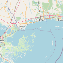
With a mobile radio all of Vancleave, and west to the Biloxi exit, and east to Moss Point. With a handheld all throughout Vancleave and a little east and west.
Website: GMRS of Jackson County, MS
Notes: Open repeater, everyone is welcome to get on and use it.
Marker
50 km
30 mi
Leaflet © OSM contributors

Exact coordinates of the repeater are not known.
Coverage circle based on mobile coverage and ignores propagation anomalies and terrain.

Signal Reports (click map icon for details): Base Mobile HT
Add a Signal Report