(1 of 4) ...The National Weather Service in Mobile AL has issued a Flood Warning for the following rivers in Mississippi... Pascagoula At Merrill affecting George, Greene and Jackson Counties. For the Pascagoula River...including Merrill...Minor flooding is forecast. * WHAT...Minor flooding is forecast. * WHERE...Pascagoula at Merrill. * WHEN...From late Tuesday night to Thursday morning. * IMPACTS...At 22.0 feet, Flood Stage. Water approaches homes in west Merrill. * ADDITIONAL DETAILS... - At 8:15 AM CDT Saturday the stage was 19.4 feet. - Forecast...The river is expected to rise to a crest of 22.0 feet early Wednesday morning. It will then fall below flood stage early Thursday morning. - Flood stage is 22.0 feet. - http://www.weather.gov/safety/flood (2 of 4) ...The Flood Warning continues for the following rivers in Mississippi... Leaf Near McLain affecting George, Greene and Perry Counties. For the Leaf River...including McLain, New Augusta...Minor flooding is forecast. * WHAT...Minor flooding is occurring and minor flooding is forecast. * WHERE...Leaf near McLain. * WHEN...Until early Wednesday morning. * IMPACTS...At 18.0 feet, Considerable flooding of agricultural and lowlands near the river. * ADDITIONAL DETAILS... - At 8:15 AM CDT Saturday the stage was 18.4 feet. - Forecast...The river is expected to rise to a crest of 19.5 feet tomorrow evening. It will then fall below flood stage Tuesday evening. - Flood stage is 18.0 feet. - http://www.weather.gov/safety/flood (3 of 4) ...The Flood Warning continues for the following rivers in Mississippi... Chickasawhay At Leakesville affecting George and Greene Counties. For the Chickasawhay River...including Waynesboro, Leakesville... Minor flooding is forecast. * WHAT...Minor flooding is occurring and minor flooding is forecast. * WHERE...Chickasawhay at Leakesville. * WHEN...Until further notice. * IMPACTS...At 26.0 feet, Flooding at the highway bridge begins. * ADDITIONAL DETAILS... - At 8:15 AM CDT Saturday the stage was 23.8 feet. - Forecast...The river is expected to rise to a crest of 24.5 feet tomorrow evening. - Flood stage is 20.0 feet. - http://www.weather.gov/safety/flood (4 of 4) ...The Flood Warning is extended for the following rivers in Mississippi... Tallahala Creek At Laurel affecting Jones County. * WHAT...Minor flooding is occurring and minor flooding is forecast. * WHERE...Tallahala Creek at Laurel. * WHEN...Until Monday morning. * IMPACTS...At 13.0 feet, Agricultural and lowland flooding is becoming more widespread along and near the creek. * ADDITIONAL DETAILS... - At 8:00 AM CDT Saturday the stage was 14.3 feet. - Forecast...The river is expected to fall below flood stage early tomorrow afternoon and continue falling to 5.2 feet Thursday morning. - Flood stage is 13.0 feet.
honey pot Ellisville, Mississippi, 224.88, W5NRU Repeater

Ellisville, MS

W5NRU
Repeater ID: 28-14791

Downlink: 224.88000
Uplink: 223.28000
Offset: -1.600 MHz
Uplink Tone: 179.9
Downlink Tone: 179.9
County: Jones
Call: W5NRU
Use: OPEN
Op Status: ON-AIR On-Air
Coverage: Ellisville, I-59 US-11 MS-29 MS-588 MS-590
30 mi radius.
Sponsor: Networked Radio User's Group - W5NRU (NRUG)
Affiliate: Networked Radio User's Group - W5NRU
Features: Linked
Emergency power equipped - Battery
FM: Yes; analog capable: 25.0 kHz (wideband)
Links:
EchoLink: 1512
👎 Node Offline
IRLP: 4115
Extended Down for 1570 days, 8 hours, 35 minutes, 48 seconds.
Commands: no RF user commands available
Notes: email user callsign for incoming EchoLink connection access - no beeps or hangtimes please
Web links: W5NRU Group Page
Last updated: 2020-11-03
Last reviewed: 2020-11-03
Marker
50 km
30 mi
Leaflet © OSM contributors

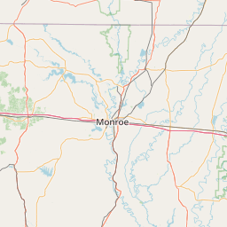
Exact coordinates of the repeater are not known.
Coverage circle based on mobile coverage and ignores propagation anomalies and terrain.

Signal Reports (click map icon for details): Base Mobile HT
Add a Signal Report


QUICK UPDATE
It's been over 2 years since we've heard if this repeater is operational.
Report repeater:

Report Heard Report Not Heard

Date Information Updated
2021-01-29 16:27:15 MS-588 coverage deleted.
2021-01-29 16:27:15 MS-590 coverage deleted.
2021-01-29 16:26:42 I-59 coverage added.
2021-01-29 16:26:42 US-11 coverage added.
2021-01-29 16:26:42 MS-29 coverage added.
2021-01-29 16:26:42 MS-588 coverage added.
2021-01-29 16:26:42 MS-590 coverage added.
2021-01-29 16:26:42 MS-588 coverage added.
2021-01-29 16:26:42 MS-590 coverage added.

Call Date Information
AA5SG (registered) 2020-11-02 Repeater re-verified. All information complete and accurate.
AA5SG (registered) 2016-09-24 managed links
AA5SG (registered) 2016-09-24 added link 28-130
AA5SG (registered) 2016-09-24 repeater placed on the air full-time for normal operation
AA5SG (registered) 2016-07-27 changed tone to 179.9-Hz.
AA5SG (registered) 2016-05-23 added trustee info