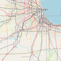
(1 of 2) ...The Flood Warning continues for the following rivers in Indiana... Illinois... Wabash River at Hutsonville Legacy Power Plant Site. Wabash River at Montezuma. Wabash River at Riverton. .Rainfall from the past few days across central Indiana will produce minor flooding along the East Fork White river. * WHAT...Minor flooding is forecast. * WHERE...Wabash River at Hutsonville Legacy Power Plant Site. * WHEN...Until early Thursday morning. * IMPACTS...At 16.0 feet, Old Darwin Road and a few low rural roads between York and Hutsonville, Illinois begin to flood. Agricultural flooding begins along portions of the river. * ADDITIONAL DETAILS... - There is no current observed data. - Forecast...The river is expected to rise to a crest of 16.6 feet early tomorrow afternoon. It will then fall below flood stage early Wednesday afternoon. - Flood stage is 16.0 feet. - http://www.weather.gov/safety/flood (2 of 2) ...The Flood Warning continues for the following rivers in Indiana... Illinois... Wabash River at Hutsonville Legacy Power Plant Site. Wabash River at Montezuma. Wabash River at Riverton. .Rainfall from the past few days across central Indiana will produce minor flooding along the East Fork White river. * WHAT...Minor flooding is forecast. * WHERE...Wabash River at Riverton. * WHEN...From late tonight to early Thursday morning. * IMPACTS...At 16.0 feet, Some agricultural lands underwater. A few rural roads in Crawford County, Illinois close as water backs up Minnow Slough. High water affects campground at Leaverton Park in Palestine. A few private roads near the Gill Township levee in Sullivan County may flood. Water level is at the top of most makeshift levees. * ADDITIONAL DETAILS... - At 10:00 PM EDT Monday /9:00 PM CDT Monday/ the stage was 14.9 feet. - Forecast...The river is expected to rise above flood stage late tonight to a crest of 15.4 feet early tomorrow afternoon. It will then fall below flood stage Wednesday afternoon. - Flood stage is 15.0 feet. - http://www.weather.gov/safety/flood
honey pot Melrose Park, Illinois, 442.625, W9FT Repeater

Melrose Park, IL

W9FT
Repeater ID: 17-164

Downlink: 442.62500
Uplink: 447.62500
Offset: +5.000 MHz
Uplink Tone: 114.8
Downlink Tone: 114.8
County: Cook
Call: W9FT
Use: OPEN
Op Status: ON-AIR On-Air
Coverage: Wide area coverage. 20 mi radius.
Sponsor: PIGFAR
Features: Linked.
FM: Yes; analog capable: 25.0 kHz (wideband)
Commands: DTMF 8161 to turn wakeup by control ops
Coordination: ILRA
ILRA Record ID: 1396
Last updated: 2025-03-20
Last reviewed: 2025-03-20

RepeaterBook partners with the Illinois Repeater Association (ILRA) to bring you accurate repeater data based on coordination records.
Data that may affect coordination cannot be updated on RepeaterBook.com, and must be submitted to the ILRA. The ILRA will process the change and provide us the updated data.

Marker
30 km
20 mi
Leaflet © OSM contributors

Exact coordinates of the repeater are not known.
Coverage circle based on mobile coverage and ignores propagation anomalies and terrain.

Signal Reports (click map icon for details): Base Mobile HT
Add a Signal Report


Call Date Information
W9FT 2014-05-13 Added input frequency, TSQ, on-air status, sponsor, commands, email, changed call sign.
KC9WPR (registered) 2013-05-16 Added off-air status.