(1 of 8) ...HIGH RISK FOR RED FLAG CONDITIONS MONDAY THROUGH AT LEAST TUESDAY OF NEXT WEEK FOR MUCH OF LOS ANGELES AND VENTURA COUNTIES... .A strong Santa Ana Wind event is expected to develop Monday and last through at least Tuesday. Humidities will lower drastically at the same time. Along with the extremely dry fuels, this will create a high risk for critical fire weather conditions and rapid fire spread with any new fires. With dry conditions lasting through Friday of next week, and additional rounds of enhanced offshore flow likely, red flag conditions are likely to continue Tuesday night through Thursday. The National Weather Service in Los Angeles/Oxnard has issued a Red Flag Warning for gusty northeast winds and low relative humidity, which is in effect from 10 AM Monday to 10 PM PST Tuesday. * WINDS...Northeast 20 to 30 mph with gusts to 45 mph, strongest along from Interstate 210 corridor to the foothills Monday night and Tuesday morning. * RELATIVE HUMIDITY...Minimum 5 to 10 percent. * IMPACTS...If fire ignition occurs, conditions are favorable for extreme fire behavior and rapid fire growth, which would threaten life and property. (2 of 8) ...HIGH RISK FOR RED FLAG CONDITIONS MONDAY THROUGH AT LEAST TUESDAY OF NEXT WEEK FOR MUCH OF LOS ANGELES AND VENTURA COUNTIES... .A strong Santa Ana Wind event is expected to develop Monday and last through at least Tuesday. Humidities will lower drastically at the same time. Along with the extremely dry fuels, this will create a high risk for critical fire weather conditions and rapid fire spread with any new fires. With dry conditions lasting through Friday of next week, and additional rounds of enhanced offshore flow likely, red flag conditions are likely to continue Tuesday night through Thursday. ...FIRE WEATHER WATCH IN EFFECT FROM TUESDAY EVENING THROUGH THURSDAY EVENING FOR GUSTY WINDS AND LOW RELATIVE HUMIDITY FOR THE VENTURA COUNTY MOUNTAINS... The National Weather Service in Los Angeles/Oxnard has issued a Red Flag Warning for strong northeast winds and low relative humidity, which is in effect from 10 AM Monday to 10 PM PST Tuesday. A Fire Weather Watch has also been issued. This Fire Weather Watch for wind and low relative humidity is in effect from Tuesday evening through Thursday evening. The Fire Weather Watch is no longer in effect. * WINDS...Northeast winds 30 to 45 mph with gusts up to 65 mph possible, strongest Monday night and Tuesday morning. Otherwise, northeast winds 20 to 35 mph with gusts to 50 mph, strongest night and morning hours. * RELATIVE HUMIDITY...Daily minimums of 3 to 10 percent with very poor overnight recoveries. * IMPACTS...If fire ignition occurs, conditions are favorable for extreme fire behavior and rapid fire growth, which would threaten life and property. (3 of 8) ...HIGH RISK FOR RED FLAG CONDITIONS MONDAY THROUGH AT LEAST TUESDAY OF NEXT WEEK FOR MUCH OF LOS ANGELES AND VENTURA COUNTIES... .A strong Santa Ana Wind event is expected to develop Monday and last through at least Tuesday. Humidities will lower drastically at the same time. Along with the extremely dry fuels, this will create a high risk for critical fire weather conditions and rapid fire spread with any new fires. With dry conditions lasting through Friday of next week, and additional rounds of enhanced offshore flow likely, red flag conditions are likely to continue Tuesday night through Thursday. ...FIRE WEATHER WATCH IN EFFECT FROM TUESDAY EVENING THROUGH THURSDAY EVENING FOR GUSTY WINDS AND LOW RELATIVE HUMIDITY FOR THE VENTURA COUNTY COAST... The National Weather Service in Los Angeles/Oxnard has issued a Red Flag Warning for strong northeast winds and low relative humidity, which is in effect from 10 AM Monday to 10 PM PST Tuesday. A Fire Weather Watch has also been issued. This Fire Weather Watch for gusty winds and low relative humidity is in effect from Tuesday evening through Thursday evening. * WINDS...Northeast winds 25 to 40 mph with gusts up to 60 mph possible, strongest in the hills Monday night and Tuesday morning. Otherwise, northeast winds 20 to 30 mph with gusts 45 to 50 mph, strongest night and morning hours. * RELATIVE HUMIDITY...Daily minimums of 5 to 15 percent with very poor overnight recoveries. * IMPACTS...If fire ignition occurs, conditions are favorable for extreme fire behavior and rapid fire growth, which would threaten life and property. (4 of 8) ...HIGH RISK FOR RED FLAG CONDITIONS MONDAY THROUGH AT LEAST TUESDAY OF NEXT WEEK FOR MUCH OF LOS ANGELES AND VENTURA COUNTIES... .A strong Santa Ana Wind event is expected to develop Monday and last through at least Tuesday. Humidities will lower drastically at the same time. Along with the extremely dry fuels, this will create a high risk for critical fire weather conditions and rapid fire spread with any new fires. With dry conditions lasting through Friday of next week, and additional rounds of enhanced offshore flow likely, red flag conditions are likely to continue Tuesday night through Thursday. ...FIRE WEATHER WATCH IN EFFECT FROM TUESDAY EVENING THROUGH THURSDAY EVENING FOR GUSTY WINDS AND LOW RELATIVE HUMIDITY FOR THE EASTERN SAN GABRIEL COUNTY MOUNTAINS... The National Weather Service in Los Angeles/Oxnard has issued a Red Flag Warning for strong northeast winds and low relative humidity, which is in effect from 10 AM Monday to 10 PM PST Tuesday. A Fire Weather Watch has also been issued. This Fire Weather Watch for wind and low relative humidity is in effect from Tuesday evening through Thursday evening. The Fire Weather Watch is no longer in effect. * WINDS...Northeast winds 25 to 40 mph with gusts of 60 to 70 mph possible, strongest Monday night and Tuesday morning. Otherwise, northeast winds 20 to 35 mph with gusts to 50 mph, strongest night and morning hours. * RELATIVE HUMIDITY...Daily minimums of 3 to 10 percent with very poor overnight recoveries. * IMPACTS...If fire ignition occurs, conditions are favorable for extreme fire behavior and rapid fire growth, which would threaten life and property. (5 of 8) ...HIGH RISK FOR RED FLAG CONDITIONS MONDAY THROUGH AT LEAST TUESDAY OF NEXT WEEK FOR MUCH OF LOS ANGELES AND VENTURA COUNTIES... .A strong Santa Ana Wind event is expected to develop Monday and last through at least Tuesday. Humidities will lower drastically at the same time. Along with the extremely dry fuels, this will create a high risk for critical fire weather conditions and rapid fire spread with any new fires. With dry conditions lasting through Friday of next week, and additional rounds of enhanced offshore flow likely, red flag conditions are likely to continue Tuesday night through Thursday. ...FIRE WEATHER WATCH IN EFFECT FROM TUESDAY EVENING THROUGH THURSDAY EVENING FOR GUSTY WINDS AND LOW RELATIVE HUMIDITY FOR THE WESTERN SANTA MONICA MOUNTAINS AND SANTA SUSANA MOUNTAINS... The National Weather Service in Los Angeles/Oxnard has issued a Red Flag Warning for strong northeast winds and low relative humidity, which is in effect from 10 AM Monday to 10 PM PST Tuesday. A Fire Weather Watch has also been issued. This Fire Weather Watch for wind and low relative humidity is in effect from Tuesday evening through Thursday evening. The Fire Weather Watch is no longer in effect. * WINDS...Northeast winds 30 to 45 mph with gusts of 60 to 80 mph possible, strongest Monday night and Tuesday morning. Otherwise, northeast winds 25 to 40 mph with gusts to 55 mph, strongest night and morning hours. * RELATIVE HUMIDITY...Daily minimums of 5 to 15 percent with very poor overnight recoveries. * IMPACTS...If fire ignition occurs, conditions are favorable for extreme fire behavior and rapid fire growth, which would threaten life and property. (6 of 8) ...HIGH RISK FOR RED FLAG CONDITIONS MONDAY THROUGH AT LEAST TUESDAY OF NEXT WEEK FOR MUCH OF LOS ANGELES AND VENTURA COUNTIES... .A strong Santa Ana Wind event is expected to develop Monday and last through at least Tuesday. Humidities will lower drastically at the same time. Along with the extremely dry fuels, this will create a high risk for critical fire weather conditions and rapid fire spread with any new fires. With dry conditions lasting through Friday of next week, and additional rounds of enhanced offshore flow likely, red flag conditions are likely to continue Tuesday night through Thursday. ...FIRE WEATHER WATCH IN EFFECT FROM TUESDAY EVENING THROUGH THURSDAY EVENING FOR GUSTY WINDS AND LOW RELATIVE HUMIDITY FOR THE WESTERN LOS ANGELES COUNTY MOUNTAINS... The National Weather Service in Los Angeles/Oxnard has issued a Red Flag Warning for strong northeast winds and low relative humidity, which is in effect from 10 AM Monday to 10 PM PST Tuesday. A Fire Weather Watch has also been issued. This Fire Weather Watch for wind and low relative humidity is in effect from Tuesday evening through Thursday evening. The Fire Weather Watch is no longer in effect. * WINDS...Northeast winds 30 to 45 mph with gusts of 65 to 80 mph possible, strongest Monday night and Tuesday morning. Otherwise, northeast winds 20 to 35 mph with gusts to 55 mph, strongest night and morning hours. * RELATIVE HUMIDITY...Daily minimums of 3 to 10 percent with very poor overnight recoveries. * IMPACTS...If fire ignition occurs, conditions are favorable for extreme fire behavior and rapid fire growth, which would threaten life and property. (7 of 8) ...HIGH RISK FOR RED FLAG CONDITIONS MONDAY THROUGH AT LEAST TUESDAY OF NEXT WEEK FOR MUCH OF LOS ANGELES AND VENTURA COUNTIES... .A strong Santa Ana Wind event is expected to develop Monday and last through at least Tuesday. Humidities will lower drastically at the same time. Along with the extremely dry fuels, this will create a high risk for critical fire weather conditions and rapid fire spread with any new fires. With dry conditions lasting through Friday of next week, and additional rounds of enhanced offshore flow likely, red flag conditions are likely to continue Tuesday night through Thursday. ...FIRE WEATHER WATCH IN EFFECT FROM TUESDAY EVENING THROUGH THURSDAY EVENING FOR GUSTY WINDS AND LOW RELATIVE HUMIDITY FOR THE EASTERN SANTA MONICA MOUNTAINS AND MOST VALLEYS OF VENTURA AND LOS ANGELES COUNTIES... The National Weather Service in Los Angeles/Oxnard has issued a Red Flag Warning for strong northeast winds and low relative humidity, which is in effect from 10 AM Monday to 10 PM PST Tuesday. A Fire Weather Watch has also been issued. This Fire Weather Watch for wind and low relative humidity is in effect from Tuesday evening through Thursday evening. The Fire Weather Watch is no longer in effect. * WINDS...Northeast winds 25 to 40 mph with gusts up to 65 mph possible, strongest Monday night and Tuesday morning. Otherwise, northeast winds 20 to 30 mph with gusts 45 to 50 mph, strongest night and morning hours. * RELATIVE HUMIDITY...Daily minimums of 5 to 15 percent with very poor overnight recoveries. * IMPACTS...If fire ignition occurs, conditions are favorable for extreme fire behavior and rapid fire growth, which would threaten life and property. (8 of 8) ...HIGH RISK FOR RED FLAG CONDITIONS MONDAY THROUGH AT LEAST TUESDAY OF NEXT WEEK FOR MUCH OF LOS ANGELES AND VENTURA COUNTIES... .A strong Santa Ana Wind event is expected to develop Monday and last through at least Tuesday. Humidities will lower drastically at the same time. Along with the extremely dry fuels, this will create a high risk for critical fire weather conditions and rapid fire spread with any new fires. With dry conditions lasting through Friday of next week, and additional rounds of enhanced offshore flow likely, red flag conditions are likely to continue Tuesday night through Thursday. ...FIRE WEATHER WATCH IN EFFECT FROM TUESDAY EVENING THROUGH THURSDAY EVENING FOR GUSTY WINDS AND LOW RELATIVE HUMIDITY FOR THE MALIBU COAST... The National Weather Service in Los Angeles/Oxnard has issued a Red Flag Warning for strong northeast winds and low relative humidity, which is in effect from 10 AM Monday to 10 PM PST Tuesday. A Fire Weather Watch has also been issued. This Fire Weather Watch for wind and low relative humidity is in effect from Tuesday evening through Thursday evening. The Fire Weather Watch is no longer in effect. * WINDS...Northeast winds 25 to 40 mph with gusts up to 60 mph possible, strongest western Malibu coast Monday night and Tuesday morning. Otherwise, northeast winds 20 to 30 mph with gusts 45 to 50 mph, strongest night and morning hours. * RELATIVE HUMIDITY...Daily minimums of 10 to 20 percent with poor overnight recoveries. * IMPACTS...If fire ignition occurs, conditions are favorable for extreme fire behavior and rapid fire growth, which would threaten life and property.
RepeaterBook.com Home Page
honey pot Ridgecrest, Randsburg Peak, California, 145.34, WA6YBN Repeater

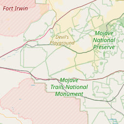
Randsburg Peak - WA6YBN
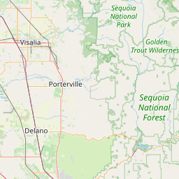
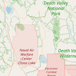
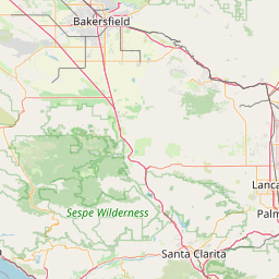
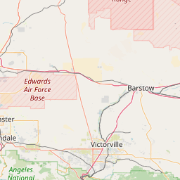
Ridgecrest, CA
Repeater ID: 06-188

Downlink: 145.34000
Uplink: 144.74000
Offset: -0.600 MHz
Uplink Tone: 100.0
County: Kern
Grid: DM15dl
Call: WA6YBN
Use: OPEN
Op Status: ON-AIR On-Air
Coverage:
Sponsor: <a href="http://www.qsl.net/wa6ybn/" rel="nofollow">Sierra ARC</a>
Features: Emergency power equipped.
FM: Yes; analog capable.
Analog Bandwidth: 25.0 kHz (wideband)
AllStar: 27179 👎 Uptime data not available.
Notes: 45' AGL, 30 watts.
Web links: SARC Repeaters
Coordination: Southern Cal FM Society (SCFMS)
Last updated: 2022-11-16
Last reviewed: 2022-11-16

Open Street Map

Exact coordinates of the repeater are known.
Coverage circle does not account for propagation anomalies or terrain.

Add a Propagation Report

- Base - HT - Mobile
Click the icons on map for details.


QUICK UPDATE
It's been over 2 years since we've heard if this repeater is operational.
Report repeater:

On-Air Off-Air Unchanged

Date Information Updated
2009-11-15 00:00:00 TASMA current. Status available on site.
2007-07-31 00:00:00 TASMA. GPS: Guessing that it is on the tower overlooking the area.

Call Date Information
N6VHF (registered) 2022-01-12 Propagation Report Added
N6HHR (registered) 2020-08-19 On-Air
KI6PSP 2010-10-03 Removed link from features.


If you have an iPhone/iPod/iPad or Android device, please download the FREE official RepeaterBook app!


Copyright © 2006-2025 RepeaterBook.com. All Rights Reserved.
Created and owned by KD6KPC/WREQ745 since 2006.
All data, including non-copyrightable data, is protected from theft under Oregon law (ORS 164.377).

Page created in 0.338370 seconds.