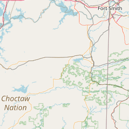
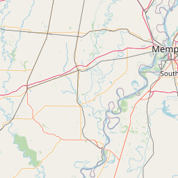
(1 of 3) ...The Flood Warning continues for the following rivers in Oklahoma... Cimarron River near Ripley affecting Payne County. * WHAT...Minor flooding is occurring and minor flooding is forecast. * WHERE...Cimarron River near Ripley. * WHEN...Until this evening. * IMPACTS...At 17.0 feet, Places along the Cimarron River valley in Payne County are briefly flooded. Agricultural lands and oil wells located near the channel are isolated by water in cutoff channels along the river valley. * ADDITIONAL DETAILS... - At 3:00 AM CDT Tuesday the stage was 17.4 feet. - Bankfull stage is 17.0 feet. - Forecast...The Cimarron River is expected to fall below flood stage this afternoon and continue falling. - Flood stage is 17.0 feet. - http://www.weather.gov/safety/flood (2 of 3) ...The Flood Warning continues for the following rivers in Oklahoma... Neosho River near Commerce affecting Ottawa County. * WHAT...Minor flooding is occurring and minor flooding is forecast. * WHERE...Neosho River near Commerce. * WHEN...Until late this evening. * IMPACTS...At 16.0 feet, minor agricultural flooding occurs. Riverview Park experiences minor flooding. * ADDITIONAL DETAILS... - At 2:30 AM CDT Tuesday the stage was 16.2 feet. - Forecast...The river is expected to fall below flood stage late this afternoon and continue falling and remain below flood stage. - Flood stage is 15.0 feet. - http://www.weather.gov/safety/flood (3 of 3) ...The Flood Warning continues for the following rivers in Oklahoma... Deep Fork River near Beggs affecting Okmulgee County. * WHAT...Minor flooding is forecast. * WHERE...Deep Fork River near Beggs. * WHEN...From late Wednesday night to late Friday evening. * IMPACTS...At 20.0 feet, minor flooding of agricultural lands occurs. Webster Road north of the gage site becomes impassable as well as some other county roads south of Beggs. * ADDITIONAL DETAILS... - At 2:15 AM CDT Tuesday the stage was 12.2 feet. - Forecast...The river is expected to rise above flood stage early Thursday morning to a crest of 19.6 feet Thursday evening. It will then fall below flood stage Friday afternoon. - Flood stage is 18.0 feet. - http://www.weather.gov/safety/flood
honey pot Liberty, Oklahoma, 444.3, W5ANR Repeater

Liberty, OK

W5ANR
Repeater ID: 40-22008

Downlink: 444.30000
Uplink: 449.30000
Offset: +5.000 MHz
Uplink Tone: 88.5
County: Sequoyah
Grid: EM25rl
Call: W5ANR
Use: OPEN
Op Status: ON-AIR On-Air
Coverage: 30 mi radius.
Sponsor: Fort Smith Area Amatuer Radio Club
FM: Yes; analog capable: 25.0 kHz (wideband)
Last updated: 2023-09-29
Last reviewed: 2024-05-12
Marker
30 km
30 mi
Leaflet © OSM contributors

Exact coordinates of the repeater are known.
Coverage circle based on mobile coverage and ignores propagation anomalies and terrain.

Signal Reports (click map icon for details): Base Mobile HT
Add a Signal Report


Call Date Details
N9EXR (registered) 2024-05-12 Reported on-air.
WX5DR (registered) 2023-09-26 Added.