(1 of 3) * WHAT...Minor flooding is forecast. * WHERE...Savannah River near Clyo. * WHEN...From late tonight to Wednesday afternoon. * IMPACTS...At 11.0 feet, the back yards of several homes on Tom Goethe Road flood. * ADDITIONAL DETAILS... - At 115 PM EDT Sunday, the stage was 10.8 feet. - Forecast...The river is expected to rise above flood stage early Monday morning to a crest of 11.1 feet Monday evening. It will then fall below flood stage early Wednesday morning. - Flood stage is 11.0 feet. (2 of 3) * WHAT...Minor flooding is forecast. * WHERE...Ogeechee River at Midville. * WHEN...From Monday evening until further notice. * IMPACTS...At 6.0 feet, the access road into the River Bluff community in Midville floods. The lower portion of Johnson Road near Herndon is also flooded. * ADDITIONAL DETAILS... - At 1100 AM EDT Sunday, the stage was 5.9 feet. - Forecast...The river is expected to rise above flood stage Monday evening and continue rising to 6.2 feet Wednesday evening. Additional rises are possible thereafter. - Flood stage is 6.0 feet. (3 of 3) ...The Flood Warning is extended for the following rivers in Georgia... Ocmulgee River near Macon affecting Twiggs, Monroe, Houston, Jones and Bibb Counties. * WHAT...Minor flooding is occurring and minor flooding is forecast. * WHERE...Ocmulgee River near Macon. * WHEN...Until late Monday night. * IMPACTS...At 19 feet, Minor flooding continues. The Macon Greenway Ocmulgee Heritage Trail will begin to flood in areas just north of the Martin Luther King Boulevard bridge. The public should not use this portion of the trail. In addition...the lowest sections of the Charles Jones Gateway Park will flood. Portions of agricultural lands well downstream will be under two feet of water. * ADDITIONAL DETAILS... - At 9:30 AM EDT Sunday the stage was 18.7 feet and rising. - Forecast...The river is expected to rise to a crest of 19 feet this afternoon. It will then fall below flood stage tomorrow evening. - Flood stage is 18 feet. - http://www.weather.gov/safety/flood
honey pot Thomasville, Georgia, 224.32, WR4SG Repeater

Thomasville, GA

WR4SG
Repeater ID: 13-292

Downlink: 224.32000
Uplink: 222.72000
Offset: -1.600 MHz
Uplink Tone: 141.3
Downlink Tone: 141.3
County: Thomas
Call: WR4SG
Use: OPEN
Op Status: ON-AIR On-Air
Coverage: 
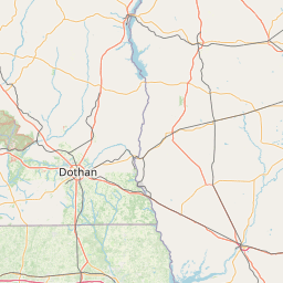
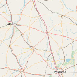
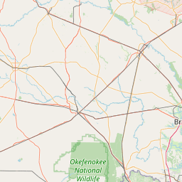
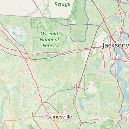
Estimated Area Coverage: Includes -- Lowndes County, GA; Brooks County, GA; Cook County, GA; Hamilton County, FL. Major Travel Routes (7): US-319, US-84, US-19, US-221, I-10, US-27, US-90.
30 mi radius.
Pattern: Omnidirectional
FM: Yes; analog capable: 25.0 kHz (wideband)
Links:
System Links:
Full-time to the 220 RAPTOR NETWORK System.
Notes: SERA Listing (as of 08 December 2023):
Callsign Frequency Offset Code Description City County
WR4SG 224.3200 -1.6 MHz 141.3 Wideband FM Thomasville Thomas

RB: Current Repeater Record Custodian (RRC) for WR4SG 224.32000 Thomasville repeater (13-292): KB0Y.
Coordination: SERA
Last updated: 2022-11-12
Last reviewed: 2023-12-08
Marker
50 km
30 mi
Leaflet © OSM contributors

Exact coordinates of the repeater are not known.
Coverage circle based on mobile coverage and ignores propagation anomalies and terrain.

Signal Reports (click map icon for details): Base Mobile HT
Add a Signal Report


Call Date Information
KB0Y (registered) 2019-12-23 Changed city, added system link