Flatwoods Mtn - KN4TRV
Dorton, KY
Repeater ID: 21-37

| Downlink: | 146.89500 |
| Uplink: | 147.49500 |
| Offset: | +0.600 MHz |
| Uplink Tone: | 127.3 |
| Downlink Tone: | CSQ |
| County: | Pike |
| Call: | KN4TRV |
| Use: | OPEN |
| Op Status: | |
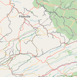
| Coverage: |
Estimated Area Coverage: Southern Pike County, KY. 14 mi radius. |
| Pattern: | Omnidirectional |
| Sponsor: | Henry Clark II (KC4KZT) |
| FM: | Yes; analog capable: 25.0 kHz (wideband) |
| Notes: | SERA Listing (as of 28 November 2023): Callsign Frequency Offset Code Description City County KN4TRV 146.8950 +0.6 MHz 127.3 Wideband FM Dorton Pike RB: Current Repeater Record Custodian (RRC) for KN4TRV 146.89500 Dorton repeater (21-37): KN4TRV. |
| Coordination: | SERA |
| Last updated: 2023-11-28 | |
| Last reviewed: 2024-10-03 | |


Exact coordinates of the repeater are
not known.
Coverage circle based on mobile coverage and ignores propagation anomalies and terrain.