(1 of 5) ...The Flood Warning continues for the following rivers in Colorado... Arkansas River At Canon City affecting Fremont County. Arkansas River At La Junta affecting Otero County. Arkansas River NEAR Avondale affecting Pueblo County. .Snow melt and increased reservoir releases will cause the river flows to become high. Expect minor flooding downstream from the dam. For the Lower Arkansas River...including Avondale, La Junta...Minor flooding is forecast. * WHAT...Minor flooding is occurring and minor flooding is forecast. * WHERE...Arkansas River near Avondale. * WHEN...Until further notice. * IMPACTS...At 7.0 feet, Minor lowland flooding occurs near Avondale. * ADDITIONAL DETAILS... - At 6:45 AM MDT Saturday the stage was 7.5 feet. - Bankfull stage is 5.0 feet. - Recent Activity...The maximum river stage in the 24 hours ending at 6:45 AM MDT Saturday was 7.5 feet. - Forecast...The river is expected to remain steady above flood stage at 7.5 feet. - Flood stage is 7.0 feet. - Flood History...This crest compares to a previous crest of 7.8 feet on 04/24/1942. - http://www.weather.gov/safety/flood (2 of 5) ...The Flood Warning continues for the following rivers in Colorado... Arkansas River At Canon City affecting Fremont County. Arkansas River At La Junta affecting Otero County. Arkansas River NEAR Avondale affecting Pueblo County. .Snow melt and increased reservoir releases will cause the river flows to become high. Expect minor flooding downstream from the dam. For the Lower Arkansas River...including Avondale, La Junta...Minor flooding is forecast. * WHAT...Minor flooding is occurring and minor flooding is forecast. * WHERE...Arkansas River at La Junta. * WHEN...Until further notice. * IMPACTS...At 11.0 feet, Minor Flood. Minor agricultural flooding. * ADDITIONAL DETAILS... - At 6:15 AM MDT Saturday the stage was 11.2 feet. - Bankfull stage is 10.0 feet. - Recent Activity...The maximum river stage in the 24 hours ending at 6:15 AM MDT Saturday was 11.3 feet. - Forecast...The river is expected to remain steady above flood stage at 11.1 feet. - Flood stage is 11.0 feet. - Flood History...This crest compares to a previous crest of 11.1 feet on 08/22/1984. - http://www.weather.gov/safety/flood (3 of 5) ...The Flood Warning continues for the following rivers in Colorado... Arkansas River At Canon City affecting Fremont County. Arkansas River At La Junta affecting Otero County. Arkansas River NEAR Avondale affecting Pueblo County. .Snow melt and increased reservoir releases will cause the river flows to become high. Expect minor flooding downstream from the dam. For the Lower Arkansas River...including Avondale, La Junta...Minor flooding is forecast. * WHAT...No flooding is currently forecast. * WHERE...Arkansas River at Canon City. * WHEN...Until further notice. * IMPACTS...At 10.0 feet, Minor flood. Minor overbank flow occurs into low lying areas along river. Water overtops screens at Canon City water supply intake * ADDITIONAL DETAILS... - At 6:15 AM MDT Saturday the stage was 9.5 feet. - Bankfull stage is 8.0 feet. - Forecast...The river is expected to remain steady below flood stage at 9.4 feet. - Flood stage is 10.0 feet. - Flood History...This crest compares to a previous crest of 9.5 feet on 05/26/1984. - http://www.weather.gov/safety/flood (4 of 5) ...RED FLAG WARNING IN EFFECT FROM 11 AM TO 10 PM MDT MONDAY FOR GUSTY WINDS, LOW RELATIVE HUMIDITY AND DRY FUELS FOR FIRE WEATHER ZONES 203, 207, 290, 291, 292, 293, 490, AND 491... The National Weather Service in Grand Junction has issued a Red Flag Warning for gusty winds, low relative humidity and dry fuels, which is in effect from 11 AM to 10 PM MDT Sunday. A Red Flag Warning has also been issued from 11 AM to 10 PM MDT Monday. The Fire Weather Watch is no longer in effect. * AFFECTED AREA...In Colorado, Fire Weather Zone 203 Lower Colorado River, Fire Weather Zone 207 Southwest Colorado Lower Forecast Area, Fire Weather Zone 290 Paradox Valley Forecast Area, Fire Weather Zone 291 Northern San Juan Forecast Area, Fire Weather Zone 292 North Fork Forecast Area and Fire Weather Zone 293 Gunnison Basin Forecast Area. In Utah, Fire Weather Zone 490 Colorado River Basin and Fire Weather Zone 491 Southeast Utah. * WINDS...Southwest 15 to 25 mph with gusts up to 45 mph. * RELATIVE HUMIDITY...6 to 11 percent. * IMPACTS...Conditions may become favorable for the easy ignition and rapid spread of fires due to low relative humidity and strong gusty winds. (5 of 5) ...RED FLAG WARNING IN EFFECT FROM 11 AM TO 10 PM MDT MONDAY FOR GUSTY WINDS, LOW RELATIVE HUMIDITY AND DRY FUELS FOR FIRE WEATHER ZONES 203, 207, 290, 291, 292, 293, 490, AND 491... The National Weather Service in Grand Junction has issued a Red Flag Warning for gusty winds, low relative humidity and dry fuels, which is in effect from 11 AM to 10 PM MDT Sunday. A Red Flag Warning has also been issued from 11 AM to 10 PM MDT Monday. The Fire Weather Watch is no longer in effect. * AFFECTED AREA...In Colorado, Fire Weather Zone 203 Lower Colorado River, Fire Weather Zone 207 Southwest Colorado Lower Forecast Area, Fire Weather Zone 290 Paradox Valley Forecast Area, Fire Weather Zone 291 Northern San Juan Forecast Area, Fire Weather Zone 292 North Fork Forecast Area and Fire Weather Zone 293 Gunnison Basin Forecast Area. In Utah, Fire Weather Zone 490 Colorado River Basin and Fire Weather Zone 491 Southeast Utah. * WINDS...Southwest 15 to 25 mph with gusts up to 45 mph. * RELATIVE HUMIDITY...6 to 11 percent. * IMPACTS...Conditions may become favorable for the easy ignition and rapid spread of fires due to low relative humidity and strong gusty winds.
RepeaterBook.com Home Page
Advertisements


honey pot Colorado Springs, Almagre Mountain, Colorado, 147.18, AA0SP Repeater

Almagre Mountain - AA0SP

Colorado Springs, CO
Repeater ID: 08-8178

Downlink: 147.18000
Uplink: 147.78000
Offset: +0.600 MHz
Uplink Tone: 100.0
County: El Paso
Grid: DM78MS
Call: AA0SP
Use: PRIVATE
Op Status: ON-AIR On-Air
Coverage: 
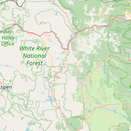
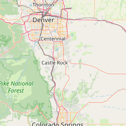
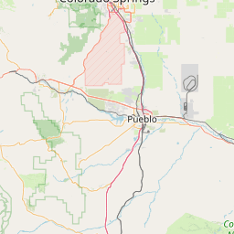
Located on South Almagre Mountain at 12,367 feet, it provides excellent coverage of nearly all of El Paso County and points east, along with coverage extending south past Pueblo. Locations very close in to the Front Range, or in the shadow of Cheyenne Mountain are not covered well. Since this peak is shorter than Pikes Peak its coverage to the north is not as good as Pikes Peak, although there are points northeast of Colorado Springs where there is coverage.
100 mi radius.
Sponsor: AA0SP
Features: E-power equipped - Solar
FM: Yes; analog capable.
Analog Bandwidth:
Notes: This repeater is available for public service oriented communications with prior coordination. Contact Mike Proctor KB0IAP to coordinate its use.
Coordination: CCARC

Open Street Map

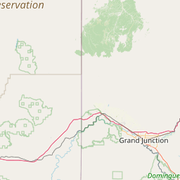
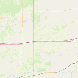
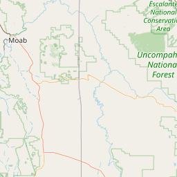
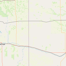
Exact coordinates of the repeater are known.
Coverage circle does not account for propagation anomalies or terrain.

Add a Propagation Report

- Base - HT - Mobile
Click the icons on map for details.


Call Date Details
K0GUR (registered) 2024-05-05 Reported on-air.


If you have an iPhone/iPod/iPad or Android device, please download the FREE official RepeaterBook app!


Advertisement

Copyright © 2006-2024 RepeaterBook.com. All Rights Reserved.
Created and owned by KD6KPC/WREQ745 since 2006.
All data, including non-copyrightable data, is protected from theft under Oregon law (ORS 164.377).

Page created in 0.066965 seconds.