(1 of 2) ...The Flood Warning is extended for the following rivers in Mississippi... Noxubee River At Macon affecting Noxubee County. * WHAT...Minor flooding is occurring and minor flooding is forecast. * WHERE...Noxubee River at Macon. * WHEN...Until late tomorrow evening. * IMPACTS...At 31.0 feet, Water covers roadway leading from cattle farmland to chicken coops downstream of Highway 45 bridge on the left side. * ADDITIONAL DETAILS... - At 8:00 AM CDT Friday the stage was 30.2 feet. - Forecast...The river is expected to fall below flood stage late tonight and continue falling. - Flood stage is 28.0 feet. - http://www.weather.gov/safety/flood (2 of 2) ...The Flood Warning is extended for the following rivers in Mississippi... Big Black River At West affecting Holmes and Attala Counties. * WHAT...Minor flooding is occurring and minor flooding is forecast. * WHERE...Big Black River at West. * WHEN...Until early Wednesday afternoon. * IMPACTS...At 17.0 feet, Several thousand acres of agricultural and lowland become inundated. * ADDITIONAL DETAILS... - At 8:45 AM CDT Friday the stage was 17.4 feet. - Forecast...The river is expected to rise to a crest of 18.0 feet tomorrow morning. - Flood stage is 15.0 feet. - http://www.weather.gov/safety/flood
honey pot Pelahatchie, Mississippi, 145.39, W5PPB Repeater

Pelahatchie, MS

W5PPB
Repeater ID: 28-90

Downlink: 145.39000
Uplink: 144.79000
Offset: -0.600 MHz
Uplink Tone: 77.0
Downlink Tone: 77.0
County: Rankin
Grid: EM52cg
Call: W5PPB
Use: OPEN
Op Status: ON-AIR On-Air
Coverage: WIDE AREA I-55, I-20, US 49 MS 25, MS 43, MS 13, MS 35, MS 18, NATCHEZ TRACE PARKWAY. Coverage includes the cities of Pelahatchie, Brandon, Pearl, Florence, Madison, Ridgeland, Jackson, Morton, Forest.
Wide area coverage. 55 mi radius.
Sponsor: W5PPB
Features: Emergency Power at site.
Emergency power equipped.
FM: Yes; analog capable: 25.0 kHz (wideband)
EchoLink: 493131 W5PPB-L
πŸ‘ ON - IDLE
Nets: Central Mississippi ARES Digital Training Net MONDAY 6:00 PM Scott County ARES Net MONDAY 7:00 PM Amateur Logic Sound Check Net TUESDAY 8 PM
Coordination: SERA
Last updated: 2021-04-24
Last reviewed: 2024-04-09
Marker
50 km
30 mi
Leaflet Β© OSM contributors

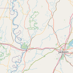
Exact coordinates of the repeater are known.
Coverage circle based on mobile coverage and ignores propagation anomalies and terrain.

Signal Reports (click map icon for details): Base Mobile HT
Add a Signal Report


Date Information Updated
2021-01-29 16:26:42 US-49 coverage added.
2021-01-29 16:26:42 I-20 coverage added.
2021-01-29 16:26:42 I-55 coverage added.
2021-01-29 16:26:42 I-220 coverage added.
2021-01-29 16:26:42 MS-25 coverage added.
2021-01-29 16:26:42 US-51 coverage added.
2021-01-29 16:26:42 US-80 coverage added.
2020-10-10 00:00:00 Nets Changed
2020-07-17 00:00:00 Amended coverage as requested - added emergency power

Call Date Details
KF0AED (registered) 2024-04-09 Reported on-air.