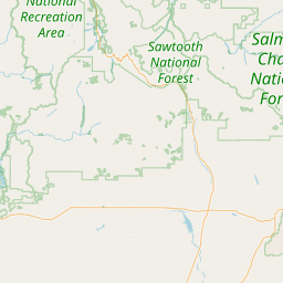
Blacks Creek Ridge - K3ZFF
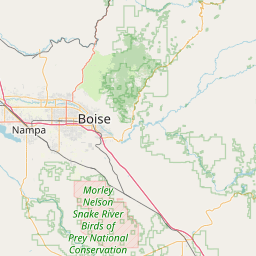
Boise, ID
Repeater ID: 16-1
| Downlink: | 145.25000 |
| Uplink: | 144.65000 |
| Offset: | -0.600 MHz |
| Uplink Tone: | 100.0 |
| Downlink Tone: | 100.0 |
| County: | Ada |
| Grid: | DN13xl |
| Call: | K3ZFF |
| Use: | OPEN |
| Op Status: | |
| Coverage: | |
| Sponsor: | Boise County Amateur Radio Club |
| FM: | Yes; analog capable: 25.0 kHz (wideband) |
| Coordination: | W7ZRQ |
| Last updated: 2024-11-26 | |
| Last reviewed: 2024-11-26 | |


Exact coordinates of the repeater are
known.
Coverage circle based on mobile coverage and ignores propagation anomalies and terrain.
This is not the true location of the repeater. This is the default pin provided by Google Maps. The repeater is described as being 15 miles east of Boise. This area does not fit that description.
on 2016-05-07.True coordinates identified by WA9WSJ, and updated on RB.
Activity
Travel
Posted by: KG7UDU
Activity
Travel
Posted by: KG7UDU