(1 of 2) ...The National Weather Service in the Twin Cities has issued a Flood Warning for the following rivers in Minnesota... Minnesota River at Morton affecting Renville and Redwood Counties. South Fork Crow River below Mayer affecting Carver County. .The convective rainfall over the last few days has swelled river levels to the point where a couple of forecast points are expected to reach minor flood stage within the next few days. With more convective rainfall on the way throughout the week, we may see a few more forecast points entering minor flood stage over the next several days. * WHAT...Minor flooding is forecast. * WHERE...Minnesota River at Morton. * WHEN...From late tonight to late Wednesday night. * IMPACTS...At 23.0 feet, Riverside Rd and Front Street flooded in North Redwood. * ADDITIONAL DETAILS... - At 800 PM CDT Sunday, the stage was 20.7 feet. - Forecast...The river is expected to rise above flood stage just after midnight tonight to a crest of 21.5 feet tomorrow evening. It will then fall below flood stage Wednesday morning. - Flood stage is 21.0 feet. - Flood History...This crest compares to a previous crest of 21.4 feet on 05/31/2004. (2 of 2) ...The National Weather Service in the Twin Cities has issued a Flood Warning for the following rivers in Minnesota... Minnesota River at Morton affecting Renville and Redwood Counties. South Fork Crow River below Mayer affecting Carver County. .The convective rainfall over the last few days has swelled river levels to the point where a couple of forecast points are expected to reach minor flood stage within the next few days. With more convective rainfall on the way throughout the week, we may see a few more forecast points entering minor flood stage over the next several days. * WHAT...Minor flooding is forecast. * WHERE...South Fork Crow River below Mayer. * WHEN...From Wednesday morning to late Saturday night. * IMPACTS...At 11.0 feet, Carver County Road 123 is closed north of Highway 7 to 42nd Street. * ADDITIONAL DETAILS... - At 830 PM CDT Sunday, the stage was 9.1 feet. - Forecast...The river is expected to rise above flood stage Wednesday morning to a crest of 11.4 feet Thursday evening. It will then fall below flood stage Saturday evening. - Flood stage is 11.0 feet. - Flood History...This crest compares to a previous crest of 11.5 feet on 05/26/2017.
honey pot Ely, Water Tower, Minnesota, 147.195, K0VRC Repeater

Water Tower - K0VRC

Ely, MN
Repeater ID: 27-17293

Downlink: 147.19500
Uplink: 147.79500
Offset: +0.600 MHz
Uplink Tone: 151.4
Downlink Tone: 151.4
WIRES-X: 28272 No matching ID is currently active.
Reflector: None found
County: St Louis
Call: K0VRC
Use: OPEN
Op Status: ON-AIR On-Air
Coverage: Ely, Tower, Babbitt, Embarrass, BWCA
Sponsor: Vemilion Range ARC
Affiliate: Lake County RACES, Vermilion Range ARES
Features: WIRES-X and Echolink
FM: Yes; analog capable: 25.0 kHz (wideband)
EchoLink: 197840
πŸ‘Ž Node Offline
Notes: To use Wires-X, disconnect from default room by DTMF #99999, wait for four beeps, then connect to desired node by DTMF (example #12345) Echolink does not require
Nets: *Tuesday 2000 Net 8pm Central
*Sunday Vermilion Range ARES Net at 7:30pm Central
Web links:
Coordination: Minnesota Repeater Council
Last updated: 2020-05-07
Last reviewed: 2020-05-07
Marker
30 km
20 mi
Leaflet Β© OSM contributors

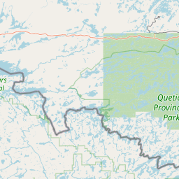
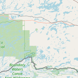
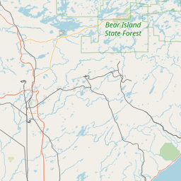
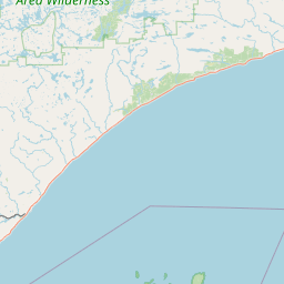
Exact coordinates of the repeater are not known.
Coverage circle based on mobile coverage and ignores propagation anomalies and terrain.

Signal Reports (click map icon for details): Base Mobile HT
Add a Signal Report


QUICK UPDATE
It's been over 2 years since we've heard if this repeater is operational.
Report repeater:

Report Heard Report Not Heard
Call Date Information
W0PHX (registered) 2020-05-07 Added Nets, Coverage, and Affiliate
W0PHX (registered) 2019-06-12 Updated several Repeater details
W0PHX (registered) 2018-09-08 Echolink and corrected grid square
W0PHX (registered) 2018-09-08 grid square