Platte City, MO
WA0QFJ
Repeater ID: 29-19919

| Downlink: | 444.55000 |
| Uplink: | 449.55000 |
| Offset: | +5.000 MHz |
| System Fusion Enabled | |
| DG-ID: | |
| WIRES-X: | 28054 No matching ID is currently active. |
| Reflector: | AMERICA-KC-WIDE |
| County: | Platte |
| Call: | WA0QFJ |
| Use: | OPEN |
| Op Status: | |
| Coverage: |
Platte and surrounding counties |
| Sponsor: | Platte County ARG |
| Features: | Emergency power equipped. |
| Notes: | Connected to Fusion Kansas City Room-Wide # 28054 |
| Last updated: 2022-07-11 | |
| Last reviewed: 2022-07-11 | |
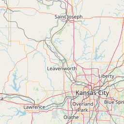


Exact coordinates of the repeater are
not known.
Coverage circle based on mobile coverage and ignores propagation anomalies and terrain.