(1 of 8) ...The Flood Warning continues for the following rivers in Oklahoma... Arkansas River near Muskogee affecting Muskogee County. * WHAT...Minor flooding is occurring and minor flooding is forecast. * WHERE...Arkansas River near Muskogee. * WHEN...Until late tomorrow morning. * IMPACTS...At 29.0 feet, minor lowland flooding occurs. A boating marina north of the OG&E power plant may be flooded. * ADDITIONAL DETAILS... - At 8:00 PM CDT Sunday the stage was 29.2 feet. - Forecast...The river is cresting and is expected to fall below flood stage late tonight. The river is then expected to drop to just below action stage and fluctuate there thru Friday. - Flood stage is 28.0 feet. - http://www.weather.gov/safety/flood (2 of 8) ...The Flood Warning is extended for the following rivers in Oklahoma... Bird Creek near Sperry affecting Tulsa and Osage Counties. Bird Creek near Owasso-Mingo affecting Tulsa County. ...The Flood Warning is cancelled for the following rivers in Oklahoma... Bird Creek at Avant affecting Osage County. * WHAT...Minor flooding is occurring and minor flooding is forecast. * WHERE...Bird Creek near Sperry. * WHEN...Until tomorrow evening. * IMPACTS...At 23.0 feet, minor rural flooding occurs from Skiatook to Turley. * ADDITIONAL DETAILS... - At 8:00 PM CDT Sunday the stage was 22.9 feet. - Forecast...The river is expected to rise to a crest of 23.5 feet tomorrow morning. It will then fall below flood stage early tomorrow afternoon. - Flood stage is 21.0 feet. - http://www.weather.gov/safety/flood (3 of 8) ...The Flood Warning is extended for the following rivers in Oklahoma... Bird Creek near Sperry affecting Tulsa and Osage Counties. Bird Creek near Owasso-Mingo affecting Tulsa County. ...The Flood Warning is cancelled for the following rivers in Oklahoma... Bird Creek at Avant affecting Osage County. * WHAT...Minor flooding is forecast. * WHERE...Bird Creek near Owasso-Mingo. * WHEN...Until late tomorrow evening. * IMPACTS...At 18.0 feet, minor flooding occurs at Mohawk Park and along 56th Street North near Mingo Road. At 19.0 feet, minor flooding occurs near Mohawk Park. 56th Street North may be impassable near Mingo Road. * ADDITIONAL DETAILS... - At 8:00 PM CDT Sunday the stage was 17.9 feet. - Forecast...The river is expected to rise above flood stage late this evening to a crest of 18.7 feet tomorrow morning. It will then fall below flood stage tomorrow afternoon. - Flood stage is 18.0 feet. - http://www.weather.gov/safety/flood (4 of 8) ...The Flood Warning continues for the following rivers in Oklahoma... Little River near Tecumseh affecting Seminole and Pottawatomie Counties. * WHAT...Moderate flooding is occurring and minor flooding is forecast. * WHERE...Little River near Tecumseh. * WHEN...Until late tomorrow evening. * IMPACTS...At 15.0 feet, Significant flooding to depths of 4 feet damages croplands... pastures... and rural roads along the river downstream of the U.S. Highway 177 bridge crossing... with lesser damage occurring upstream of U.S. Highway 177. The area affected is entirely rural... and downstream of Lake Thunderbird... from near Macomb in Pottawatomie County to near Bowlegs in western Seminole County. * ADDITIONAL DETAILS... - At 7:30 PM CDT Sunday the stage was 15.2 feet. - Bankfull stage is 11.0 feet. - Forecast...The Little River is expected to fall below flood stage tomorrow afternoon and continue falling. - Flood stage is 11.0 feet. - http://www.weather.gov/safety/flood (5 of 8) ...The National Weather Service in Tulsa OK has issued a Flood Warning for the following rivers in Oklahoma... Deep Fork River near Beggs affecting Okmulgee County. * WHAT...Minor flooding is forecast. * WHERE...Deep Fork River near Beggs. * WHEN...From Tuesday evening until further notice. * IMPACTS...At 20.0 feet, minor flooding of agricultural lands occurs. Webster Road north of the gage site becomes impassable as well as some other county roads south of Beggs. * ADDITIONAL DETAILS... - At 7:15 PM CDT Sunday the stage was 13.5 feet. - Forecast...The river is expected to rise above flood stage late Tuesday evening and continue rising to a crest of 20.5 feet early Friday morning. It will then begin to slowly fall by midday Friday but is expected to remain above flood stage thru Friday. - Flood stage is 18.0 feet. - http://www.weather.gov/safety/flood (6 of 8) ...The Flood Warning continues for the following rivers in Oklahoma... Cimarron River near Ripley affecting Payne County. * WHAT...Minor flooding is occurring and moderate flooding is forecast. * WHERE...Cimarron River near Ripley. * WHEN...Until late Wednesday morning. * IMPACTS...At 21.0 feet, The Cimarron River valley in Payne County is covered by flood depths averaging 4 feet... with hazardous currents. Agricultural lands... oil wells... and water wells located near the river banks are inundated or cut off... from several hours before to several hours after the crest passes Ripley. * ADDITIONAL DETAILS... - At 7:00 PM CDT Sunday the stage was 19.0 feet. - Bankfull stage is 17.0 feet. - Forecast...The Cimarron River is expected to rise to a crest of 21.3 feet tomorrow evening. It will then fall below flood stage early Wednesday morning. - Flood stage is 17.0 feet. - http://www.weather.gov/safety/flood (7 of 8) ...The Flood Warning continues for the following rivers in Oklahoma... Cimarron River near Dover affecting Kingfisher and Logan Counties. * WHAT...Minor flooding is forecast. * WHERE...Cimarron River near Dover. * WHEN...From late tonight to tomorrow afternoon. * IMPACTS...At 17.0 feet, Rural lands and roads are covered by flood depths averaging almost a foot across Kingfisher County... and into western Logan County. Oil wells in lower places near the river channel are flooded or isolated. Livestock may become stranded by deeper flows in cutoff channels crossing the flood plain. Sandpit facilities near Dover could be flooded. * ADDITIONAL DETAILS... - At 7:30 PM CDT Sunday the stage was 16.3 feet. - Bankfull stage is 17.0 feet. - Forecast...The Cimarron River is expected to rise above flood stage just after midnight tonight to a crest of 17.3 feet tomorrow morning. It will then fall below flood stage late tomorrow morning. - Flood stage is 17.0 feet. - http://www.weather.gov/safety/flood (8 of 8) ...The Flood Warning continues for the following rivers in Oklahoma... Neosho River near Commerce affecting Ottawa County. * WHAT...Minor flooding is occurring and minor flooding is forecast. * WHERE...Neosho River near Commerce. * WHEN...Until early Wednesday morning. * IMPACTS...At 17.0 feet, minor agricultural flooding occurs. Riverview Park experiences minor flooding. At 18.0 feet, moderate agricultural flooding occurs with Riverview Park experiencing minor to moderate flooding. Low lying places around Miami may be cut off from easy access. * ADDITIONAL DETAILS... - At 7:30 PM CDT Sunday the stage was 16.3 feet. - Forecast...The river is expected to rise to a crest of 17.7 feet early tomorrow afternoon. It will then fall below flood stage late Tuesday evening. - Flood stage is 15.0 feet. - http://www.weather.gov/safety/flood
honey pot Talihina, Sycamore Mtn, Oklahoma, 145.41, N5CST Repeater

Sycamore Mtn - N5CST

Talihina, OK
Repeater ID: 40-4522

Downlink: 145.41000
Uplink: 144.81000
Offset: -0.600 MHz
Uplink Tone: 88.5
County: Le Flore
Grid: EM24ns
Call: N5CST
Use: OPEN
Op Status: ON-AIR On-Air
Coverage: Eastern Oklahoma and Western Arkansas
Sponsor: Leflore County Emergency Management
FM: Yes; analog capable: 25.0 kHz (wideband)
Nets: Fort Smith 146.640 net: Thu at 20:00.
Coordination: ORSI
Last updated: 2023-04-12
Last reviewed: 2024-12-30
MarkerMarkerMarkerMarkerMarkerMarker
50 km
30 mi
Leaflet © OSM contributors

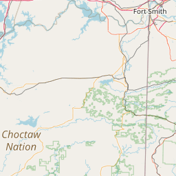
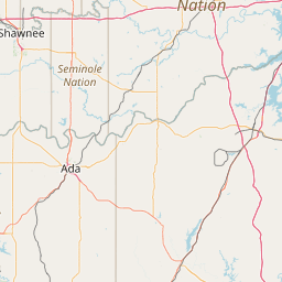
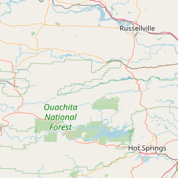
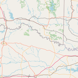
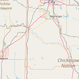
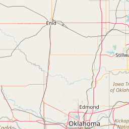
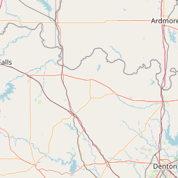
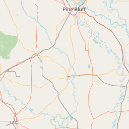
Exact coordinates of the repeater are known.
Coverage circle based on mobile coverage and ignores propagation anomalies and terrain.

Signal Reports (click map icon for details): Base Mobile HT
Add a Signal Report


Date Information Updated
2011-08-22 00:00:00 Archive per ORSI.

Call Date Details
KJ5BGQ (registered) 2024-12-31 Propagation Report Added
WB9CSP (registered) 2024-11-02 Propagation Report Added
N9EXR (registered) 2024-05-25 Reported no changes
KJ5DWA 2024-02-27 Propagation Report Added
KC5DJR (registered) 2023-09-16 Propagation Report Added

(member) on 2013-09-22.

I personally have had the opportunity to test some coverage, it really reaches out! Mobile was equipped with 50 watt radio and 5/8 wave antenna. Route tested 270 west of McAlester to Seminole. Ragged 85% of trip. 73

Category Definitions
Comments
Coverage
Activity
Travel
"Excellent System and Coverage. Monitored by hams."
Posted by: KF5IRG