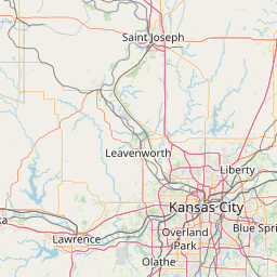
(1 of 3) At 854 PM CDT, severe thunderstorms were located along a line extending from 6 miles northwest of Bedford to near Maryville to near Skidmore, moving northeast at 40 mph. HAZARD...60 mph wind gusts. SOURCE...Radar indicated. IMPACT...Expect damage to roofs, siding, and trees. Locations impacted include... Maryville, Burlington Junction, Hopkins, Ravenwood, Skidmore, Braddyville, Conception Junction, Parnell, Clearmont, Pickering, Clyde, Arkoe, and Quitman. (2 of 3) ...The Flood Warning is extended for the following rivers in Missouri... Osage River at Taberville affecting Vernon and St. Clair Counties. For the Osage River...including Taberville...Minor flooding is forecast. * WHAT...Minor flooding is occurring and minor flooding is forecast. * WHERE...Osage River at Taberville. * WHEN...Until Monday morning. * IMPACTS...At 23.3 feet, The handicapped access to the Osage River launch near Taberville floods. * ADDITIONAL DETAILS... - At 7:45 PM CDT Saturday the stage was 23.8 feet. - Bankfull stage is 23.0 feet. - Forecast...The river is expected to fall below flood stage tomorrow morning and continue falling to 16.1 feet Thursday evening. - Flood stage is 23.0 feet. - http://www.weather.gov/safety/flood (3 of 3) ...The Flood Warning continues for the following rivers in Missouri... Blackwater River near Blue Lick affecting Cooper and Saline Counties. * WHAT...Minor flooding is occurring and minor flooding is forecast. * WHERE...Blackwater River near Blue Lick. * WHEN...Until late tomorrow evening. * IMPACTS...At 24.0 feet, Cropland and pastures along the river flood. * ADDITIONAL DETAILS... - At 5:45 AM CDT Saturday the stage was 24.9 feet. - Forecast...The river is expected to rise to a crest of 25.3 feet this afternoon. It will then fall below flood stage late this evening. - Flood stage is 24.0 feet. - http://www.weather.gov/safety/flood
RepeaterBook.com Home Page
Advertisements


honey pot Lee's Summit, Missouri, 147.315, K0HAM Repeater

Lee's Summit, MO

K0HAM
Repeater ID: 29-5680

Downlink: 147.31500
Uplink: 147.91500
Offset: +0.6 MHz
YSF Digital Enabled
DG-ID: 00 - Open
WIRES-X: 28054
County: Jackson
Grid: EM28SV
Call: K0HAM
Use: OPEN
Op Status: ON-AIR On-Air
Coverage: Lee's Summit and surrounding areas.
15 mi radius.
Notes: Connected full-time to Kansas City Room-Wide #28054. PLEASE do not attempt to change rooms!
Coordination: MRC

Open Street Map

Exact coordinates of the repeater are known.
Coverage circle does not account for propagation anomalies or terrain.

Add a Propagation Report

- Base - HT - Mobile
Click the icons on map for details.


Call Date Details
W0FH (registered) 2022-06-30 updated website


If you have an iPhone/iPod/iPad or Android device, please download the FREE official RepeaterBook app!


Advertisement

Copyright © 2006-2024 RepeaterBook.com. All Rights Reserved.
Created and owned by KD6KPC/WREQ745 since 2006.
All data, including non-copyrightable data, is protected from theft under Oregon law (ORS 164.377).

Page created in 0.045927 seconds.